
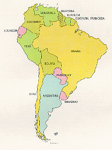
A Privileged Geographical Location
Colombia, the main port of entry to South America, is located right in
the center of the planet, over the equatorial line at the north
westernmost tip of the South American continent . It has an area of
1´141.748 sq. kms. and a population of approximately 36 million people.
It is the fourth largest in area and the second in population in all South
America.


Colombia is composed by five large natural
regions: The Atlantic
Coast, the Pacific Coast, the Orinoco River Basin (Orinoquia), the
Amazon River Basin (Amazonia) and the Andean Region. In this last
region is where 70% of the country’s population is settled.
Mother Nature blessed Colombia with all
levels, climates and natural elements
of the planet. Colombia covers just 1 % of the surfaces of the earth;
nevertheless, it boasts 10 % of all flora and fauna of the world. Three
mountain systems, access to the amazon river, extensive coast over two
oceans, Amazon jungle, countless high plains, immense valleys, prairies,
deserts, a great wealth of water resources, shelter to 49.000 flora species and
1721 species of birds. It holds second place in the world in varieties of
amphibious and third in reptiles.
Colombia shares borders with five nations: Venezuela, Brazil, Ecuador, Peru,
and Panama.
The capital city is Santafé de Bogotá, District Capital and it has a population
of 6 million people. It has an altitude of 8.524 feet above sea level with an
average temperature of 57ş F.. Medellin is the second city in the country; it
has 2 million people and an altitude of 5000 feet. Its average temperature is 68
ş F. The third largest city is Cali with the population of 2 million people. The
most important port over the Pacific Ocean, Buenaventura, where 60 % of all
import-export activity is handled is less than a 2-hour drive from Cali.
In terms of infrastructure, transportation and communications, Colombia is
definitely a modern country: six international airports, three large seaports
where 41 international companies and five national companies operate.
Besides, Colombia has a highway system of approximately 70.000 miles.
More than 500 towns in Colombia have access to direct telephone service that
connects them with 150 countries. Television signal gets to 95 % of the
national territory thanks to satellite transmissions and microwave servers.
Colombia has the world’s second largest network of land television.
transmission.
GEOGRAPHICAL REFERENCES
Coordinates
Latitude 4o, 35’,56’’.57 North
Longitude 74o, 04’,51’’.30 West
Population
35,8 million
Area
1'141.748 sq. kms.
Capital
Santafé de Bogotá
Urban Population
70 %
Cities with the population of more than 100.0000:
37
International Airports
Santafé de Bogotá, Medellin, Cali, Barranquilla,
Cartagena, and San Andres.
Main seaports:
Buenaventura, Cartagena, and Barranquilla
GENERAL INFORMATION ABOUT OUR COUNTRY
Name: Republic of Colombia
Capital: Santafé de Bogotá D.C.
Most Important Cities: Medellin, Cali, and Barranquilla
Location: It belongs to South America
Climate: tropical with tinges of change caused by altitude
Area: 1.138.914.
Government: Republic
Chief Executive and President: Andres Pastrana Arango
Independence Day: 20 of July of 1810
Religion: Catholicism 95.4 %
Language: Spanish
Population: 33’420.000 people. The majority of this population is
mestizo 58
%, white 20 %, mulatto12 %, Negro and Amerindian 10 %
Economy: Agriculture (coffee). Oil and minerals (emeralds)
Currency: peso (feb.1997:1074,50=1 .US)
GNP: US $ 51 billion
Literacy rate: 80 %
Exports: US $ 8 billion
Imports: US $ 7 billion
Overseas reserves: US $ 382 billion